Drone Harmony Platform 企業級數據採集軟體平台
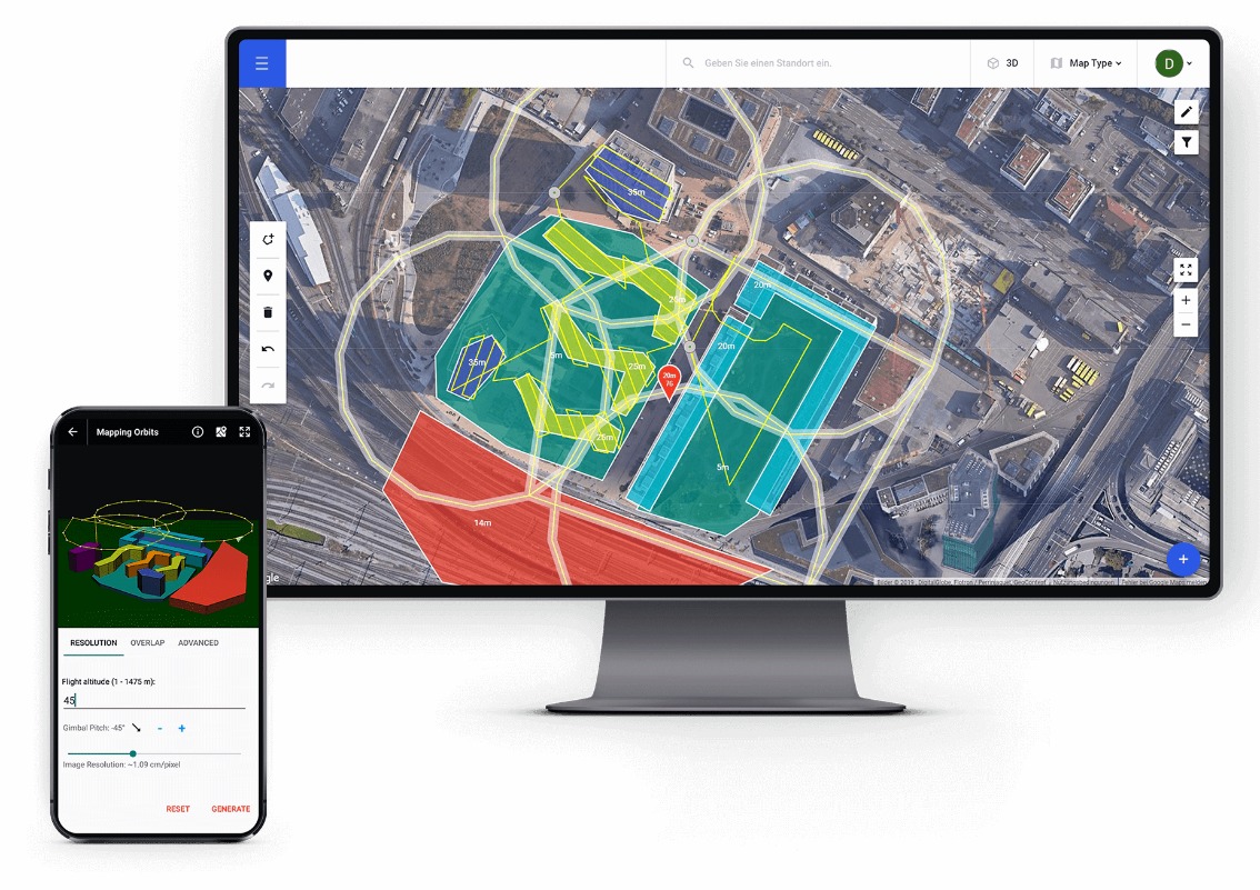
Drone Harmony 是一個由三個產品組成的平台:Drone Harmony Mobile、Drone Harmony Web和 Drone Harmony Cloud。Drone Harmony Platform 一個完整的軟體平台,可自動規劃和操作您的 3D 無人機數據採集工作流程。從網絡瀏覽器或移動設備訪問從企業範圍視圖到個人飛行計劃的所有內容。利用市場上最先進的地形感知飛行計劃,更好地進行基於無人機的測繪和線性基礎設施檢查。
Repeatable and Reliable Process
Gather the same high-quality data every time, regardless of the operator.
Swiss Safety and Data Security
State of the art data security and on-premise system installation.
Built for Collaboration
Enable easy collaboration between engineers and field operators within your organization.
Quality and Scale through Automation
Reduce manual work to a minimum to ensure quality results are achieved at scale.
Mobile, Web and Cloud
A multi-platform system always at your fingertips whether you are in the office, or in the field.

Base Your Decisions on Better Data
Feed you workflow with reliable and consistent drone data from hundreds of assets and inspections. Leverage the most advanced data capture automation software on the market to simplify planning & execution of complex drone flights.
A Tool for Each Stakeholder
Plan your drone capture workflows from the web browser, or the mobile device. Equip each stakeholder in your organization, from the inspection engineer to the field operator, with a tool tailored for their exact needs. Coordinate work seamlessly using automated cloud synchronization tools.
Visualize in 3D
Plan each stage of the workflow in an intuitive 3D interface. Easily model or import complex 3D geo-referenced structures to gain immediate visual insight into the inspection asset, flight plan and environment. Leverage data integrations to add context to your inspection site and improve the quality of the resulting data product.
Scalable solution
Automate collaboration and sharing of data and missions. Train your pilots in less than 30 minutes.
High quality data
Full coverage and accurate images guaranteed by optimization algorithms.
Save costs
Capture just the right amount of high-quality data in every flight.
Reduce Risks
Eliminate errors caused by manual workflows by using automated planing and execution algorithms.
What makes Drone Harmony different or better than other apps?
Drone Harmony is unique in several ways that make it both more automated and more intuitive than other solutions. This allows gathering data in much more complex environments than was previously possible in a repeatable and reliable way. The main aspects that differentiate Drone Harmony from other applications are:
- A web application and mobile application that are fully synchronized via the DH Cloud for storing and sharing flight plans and scenes
- A multitude of working interfaces: 2D Map, 3D and 3D Terrain view
- A scene-centered workflow and automatic mission generation
- A tailored mission planning options for specific use cases
- Real FULL-3D scene visualization and simulation environment, allowing pilots to see where the pictures will be taken
- An ability to consume 3D data, in order to automatically generate the best quality images, flight plans and safe autonomous flight execution
- Obstacle avoidance, based on the ability to consume the 3D environment
- Integration with airspace data (Unmanned Traffic Management – UTM) from Altitude Angels, enhancing flight safety and adding airspace awareness.
- Integration with Airbus WorldDEM (Digital Elevation Model) for terrain aware flights anywhere around the world.
- Unique terrain aware flight plans, even for steep and highly irregular terrain (Hill Scan)
- The largest flight plan catalog for Cell Tower inspections
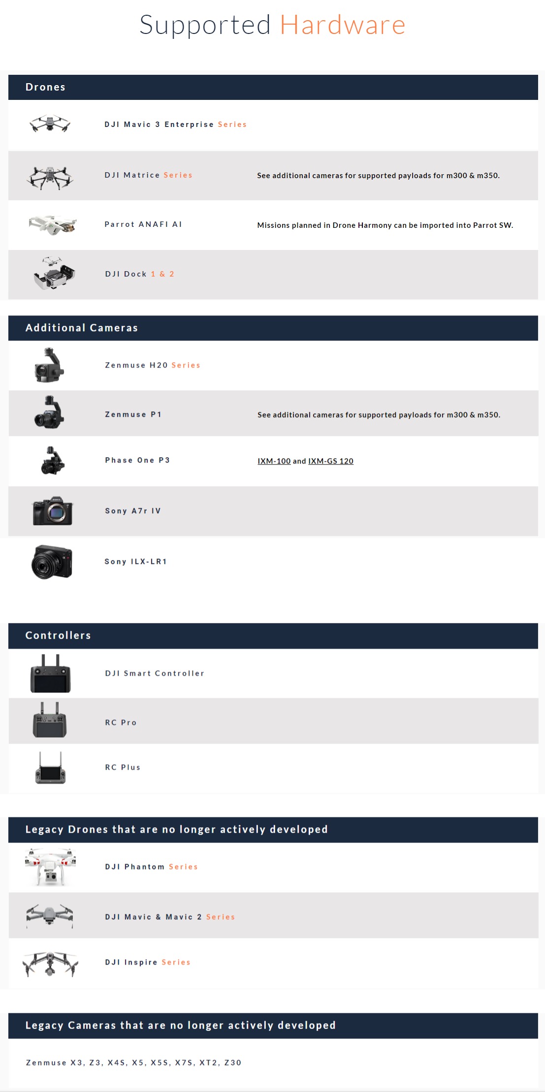
- Support of almost all DJI drones
- An integration with Open Street Maps for automatic extraction of building data
- Ability to import custom maps as maps overlay
| Starter | Professional | Enterprise |
| A complete starter package for automated drone data capture. | Fully featured 3D data capture platform for extensive drone operations requiring terrain data and high-end professional drones. | Reliable and safe drone data capture on an enterprise scale, with custom integrations, tailored planning features and unlimited data use. |
|
DJI Mavic 3 Enterprise series DJI Matrice 30 series DJI Mavic 2 & Phantom 4 Series DJI Mini 2, DJI Mini 3, Mini 3 pro Parrot Anafi Ai ≤100MB Custom terrain data processing & storage 50 GB image storage Up to 1 km2 / month Airbus WorldDEM 12 meter grid global data ≤ 1GB Custom map overlay processing & storage (GeoTiffs, *.tiff) Android App for flight planning & execution Web portal for flight planning A comprehensive catalog of automated missions Airspace Safety Information (UTM) |
All drones from a starter-level subscription DJI M300/M350 series DJI M200/210 series Parrot Anafi AI Access to high-quality country-wide terrain data sets in Australia, Austria, France, Italy, Norway, Switzerland ≤ 1GB Custom terrain data processing & storage 500 GB image storage Up to 5 km2 / month Airbus WorldDEM 12 meter grid global data ≤ 5GB Custom map overlay processing & storage (GeoTiffs, *.tiff) Android App for flight planning & execution Web portal for flight planning A comprehensive catalog of automated missions Airspace Safety Information (UTM) |
Any drone and Payload available in the supported hardware list Custom payloads for DJI M300/M350 series (Phase One, Sony) Enterprise catalog of automated missions Asset Inspector - enterprise workflow for distributed asset inspections Power Scanner for transmission lines and poles Cell tower inspections Team management functionality Point-cloud-based flight planning Custom terrain data processing & storage Custom image storage Custom access to Airbus WorldDEM 12-meter grid global data Custom map overlay processing & storage (GeoTiffs, *.tiff) Access to high-quality country-wide terrain data sets in Australia, Austria, France, Italy, Norway, Switzerland Android App for flight planning & execution Web portal for flight planning Airspace Safety Information (UTM) |
*Please refer to our supported Hardware page for a comprehensive overview.


