最新版 SMS 13.3.12 更新於 2024/7/10
最新版 WMS 11.2.11 更新於 2024/7/10
最新版 GMS 10.8 更新於 2024/7/10

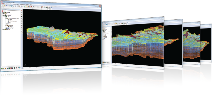
GMS - Groundwater Modeling System
GMS 是最尖端的和全功能的地下水模擬軟體,數以千計的人在全世界90多個國家使用在政府機關、私人公司和國際站點等,它已被證明是一個有效率的和令人興奮的模擬系統。
GMS提供每一個階段的地下水模擬功能,包括工地的表徵模型開發、校準以及後置處理和可視化。GMS也提供在二維和三維的有限微分和有限元素法模型包括MODFLOW 2000, MODPATH, MT3DMS/RT3D, SEAM3D, ART3D, UTCHEM, FEMWATER, PEST, UCODE, MODAEM 和 SEEP2D。不論你需要哪些模擬功能,GMS都能滿足你。
GMS的模組化設計能讓使用者只選擇他們所需要的地下水模擬功能,還可以隨時填購其他模組。該軟體運作時還可以動態自動連結到後續所添增的模組
特色
3D visualization optimized for performance
GMS is the most advanced software system available for performing groundwater simulations in a three-dimensional environment.
- Interact with models in true 3D
- Optimized OpenGL graphics for improved hardware rendering
- Create photo-realistic renderings
- Generate animations for PowerPoint or web presentations
- Drape images over the model and control the opacity
- Annotations – Add north arrows, scale bars, reference images, company logos, and more
Import a variety of data formats & imagery
Models require data from many different sources. That’s why GMS is built to easily import numerous file types:
- Raster images including georeference and projection support
- Topographical maps & elevation data
- Borehole data including stratigraphy and geophysical data
- Native MODFLOW files
- MODFLOW files from Visual MODFLOW, Groundwater Vistas and PM Win
- Web data services such as TerraServer
- ArcGIS geodatabases and shapefiles
- CAD files including .dwg, .dgn, and .dxf formats
- Worldwide projection support including Cartesian and Geographic Systems
- File Import wizard for delimited text files and spreadsheets
Advanced subsurface characterization
From cross-section editing to advanced probability statistics, GMS offers unparalleled subsurface modeling tools.
- Generate iso-surfaces from 3D data to visualize plumes
- Cut cross-sections anywhere through 3D data
- 2D & 3D geostatistics – Kriging, IDW and Natural Neighbor
- Robust and fast algorithms to create solids from horizons
系統需求
GMS 10.8 System Requirements
► Operating System: Windows 11
► RAM: 16GB or more recommended
► CPU: GMS software is CPU intensive. Some models and utilities integrated with GMS can take advantage of multiple processor cores simultaneously. We recommend the fastest CPU your budget allows.
► Storage: Recommended storage amount will vary depending on individual data requirements. Latest versions of GMS are very disk I/O intensive.
- Mechanical hard drive: Basic performance
- SATA solid state drive: Better performance
- NVMe solid state drive: Best performance
► Graphics: A dedicated graphics card is better than integrated graphics. A basic or mid-range nVidia card designed for gaming works best.
► Display Resolution: 1920 x 1080 or greater
版本比較
| MODFLOW | MODFLOW+ | MODFLOW Pro | Premium | |
| GMS Core Components | ||||
| - 3D Grid Tools | V | V | V | V |
| - 3D Animation Tools | V | V | V | V |
| - Conceptual Modeling Tools | V | V | V | V |
| - Online Maps | V | V | V | V |
| - GIS Tools | V | V | V | V |
| - CAD / Image / DEM Support | V | V | V | V |
| - Annotations Tools | V | V | V | V |
| MODFLOW Modeling | ||||
| Traditional Grid | ||||
| - MODFLOW Model & Interface | V | V | V | V |
| - MODFLOW-LGR Model & Interface | V | V | V | V |
| - ZoneBudget Utility | V | V | V | V |
| - MODPATH Model & Interface | V | V | V | V |
| - MT3DMS Model & Interface | V | V | V | V |
| - MT3D-USGS Model & Interface | V | V | V | V |
| - RT3D Model & Interface | Add-on | V | V | |
| - SEAWAT Model & Interface | Add-on | V | V | |
| - PHT3D Model & Interface | Add-on | V | V | |
| - SEAM3D Model & Interface | Add-on | V | V | |
| Unstructured Grid | ||||
| - MODFLOW-USG Model & Interface | V | V | V | V |
| - mod-PATH3DU Model & Interface | V | V | V | V |
| - MODFLOW-USG-Transport Model & Interface |
V | V | V | |
| - MODFLOW 6 Model & Interface | V | V | V | V |
| MODFLOW Utilities | ||||
| - PEST Utility - Single or Multi Core | V | V | V | V |
| - SAMG-Modflow Solver | Add-on | Add-on | Add-on | V |
| - SAMG-Modflow+ Add-on | Add-on | Add-on | Add-on | Add-on |
| Site Characterization | ||||
| - Geostatistics & Scatter Data Tools | Add-on | V | V | V |
| - Subsurface Characterization Tools | Add-on | V | V | V |
| • Stochastic Modeling Tools | Add-on | V | V | V |
| • T-PROGS Utility | Add-on | V | V | V |
| Additional Models | ||||
| - HydroGeoSphere (HGS) Model & Interface | Add-on | Add-on | Add-on | Add-on |
| - MODAEM Model & Interface | V | |||
| - Finite Element Mesh Tools | V | V | ||
| • FEFLOW Geometry | V | V | ||
| • TOUGH2 Geometry | V | V | ||
| • FEMWATER Model & Interface | V | |||
| • SEEP2D Model & Interface | Add-on | V | ||
| Maintenance | ||||
| - First year of maintenance included | V | V | V | V |
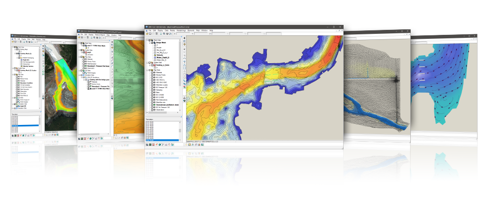
SMS - The Complete Surface-water Solution
地表水模型系統(SMS)是一個全功能的環境,支援一、二、三維水動力模型。在地表水的模擬設計也能做到前後置處理,SMS功能包括在二維的有限元素、有限元素和三維的有限元素模擬工具。支持的模組包括RMA2,RMA4,ADCIRC,CGWAVE,STWAVE,BOUSS2D,CMS的流量,這個全面性的界面也已制定了促進利用FHWA委託分析FESWMS。該TUFLOW數值模擬功能提供具有強大的洪水分析,波形分析,颶風分析等。SMS還包含一個通用的模組界面,可用於支援的模組,尚未被正式納入該系統。
SMS所支援的的模擬數值功能可算出各種適用的於地表水模擬的資訊。主要應用的模組包括為穩定狀態或動態條件計算出水面高程計算和流動速度的淺水流動問題。其它應用包括模擬污染物遷移,鹽水入侵,輸沙(沖淤),波浪能量分散,波動性(方向,大小和振幅)等。
特色
Flexible modeling approaches
Aquaveo pioneered the conceptual model approach. Build a conceptual model in SMS by constructing a high level representation of the model using familiar GIS objects: points, arcs and polygons. Work with large, complex models in a simple and efficient manner by using the conceptual modeling approach and easily update or change the model as needed.
SMS also has powerful tools to build meshes and grids.
3D visualization optimized for performance
SMS is the most advanced software system available for performing surface-water simulations in a three-dimensional environment.
- Interact with models in true 3D
- Optimized OpenGL graphics for improved hardware rendering
- Create photo-realistic renderings
- Generate animations for PowerPoint or web presentations
- Drape images over the model and control the opacity
- Annotations – Add north arrows, scale bars, reference images, company logos, and more
Import a variety of data formats & imagery
Models require data from many different sources. That’s why SMS is built to easily import numerous file types:
- Raster images including georeference and projection support
- Topographical maps & elevation data
- Elevation & bathymetry data
- Web data services such as TerraServer
- ArcGIS geodatabases and shapefiles
- CAD files including .dwg, .dgn, and .dxf formats
- Worldwide projection support including Cartesian and Geographic Systems
- File Import wizard for delimited text files and spreadsheets
Advanced riverine & coastal modeling
SMS interfaces with a wide range of numerical models for applications including:
- Riverine analysis
- Contaminant transport
- Sediment transport
- Particle tracking
- Rural & urban flooding
- Estuarine
- Coastal circulation
- Inlet & wave modeling
Software from an Industry Leader
SMS is developed by Aquaveo, an engineering services company with many years of experience developing surface-water modeling solutions.
- Step-by-step tutorials and how-to videos
- Online community forum and product documentation
- Phone and email technical support
- Regularly scheduled training courses taught by expert modelers
- On-site training available
- Professional consulting services
系統需求
SMS 13.3 System Requirements
» Operating System: Windows 11
» RAM: 16GB or more recommended
» CPU: SMS software is CPU intensive. Some models and utilities integrated with SMS can take advantage of multiple processor cores simultaneously. We recommend the fastest CPU your budget allows.
» Storage: Recommended storage amount will vary depending on individual data requirements. Latest versions of SMS are very disk I/O intensive.
- Mechanical hard drive: Basic performance
- SATA solid state drive: Better performance
- NVMe solid state drive: Best performance
» Graphics: A dedicated graphics card is better than integrated graphics. A basic or mid-range nVidia card designed for gaming works best.
» Display Resolution: 1920 x 1080 or greater
版本比較
| Riverine Pro | River & Coast | Build Your Own* | |
| SMS Core Components | |||
| - Map, GIS, Annotations Module | V | V | V |
| - Mesh Module | V | V | V |
| - Grid Module | V | V | V |
| - Scatter Module | V | V | V |
| Professional 3D Rendering and Display Options | V | V | V |
| Advanced Mesh Generation Methods and Mesh Quality Tools | V | V | V |
| Dataset Toolbox and Analysis Functions | V | V | V |
| Multi-simulation Management | V | V | V |
| Calibration Tools and 2D Plots | V | V | V |
| Riverine Models | |||
| - SRH-2D Model & Interface | V | V | Add-on |
| - SRH-2D Sediment Interface | Add-on | Add-on | Add-on |
| - HEC-RAS 2D Geometry Import & Export | V | V | Add-on |
| - HEC-RAS 1D Model Export | V | V | Add-on |
| - RMA2 Model & Interface | V | V | Add-on |
| - RMA4 Model & Interface | Add-on | Add-on | Add-on |
| - ADH Model & Interface | Add-on | Add-on | Add-on |
| - MIKE21 Geometry Import | V | V | V |
| - - Generic Model Interface | Add-on | Add-on | Add-on |
| - HYDRO_AS-2D Model**** | Add-on | Add-on | Add-on |
| Coastal Models | |||
| - ADCIRC Model | Add-on | V | Add-on |
| - ADCIRC Interface | Add-on | V | Add-on |
| - STWAVE Model & Interface | Add-on | V | Add-on |
| - CMS Flow Model & Interface | Add-on | V | Add-on |
| - CMS Wave Model & Interface | Add-on | V | Add-on |
| - WAM Model & Interface | Add-on | Add-on | Add-on |
| - CGWAVE Model & Interface | Add-on | Add-on | Add-on |
| - BOUSS2D Model & Interface | Add-on | V | Add-on |
| - GENCADE Model & Interface | Add-on | Add-on | Add-on |
| Riverine & Coastal Models | |||
| - TUFLOW FV Model (Local 1) | Add-on | Add-on | Add-on |
| • TUFLOW FV GPU Module (Local 1) | Add-on | Add-on | Add-on |
| • TUFLOW FV AD Module (Local 1) | Add-on | Add-on | Add-on |
| - TUFLOW Model & Interface (Local 1) | Add-on | Add-on | Add-on |
| • TUFLOW AD Module & Interface (Local 1) | Add-on | Add-on | Add-on |
| • TUFLOW M2D/QT Module (Local 1) | Add-on | Add-on | Add-on |
| • TUFLOW GPU Module (Local 1) | Add-on | Add-on | Add-on |
| Particle Tracking Model | |||
| - PTM Model & Interface | Add-on | Add-on | Add-on |
| Maintenance | |||
| - First year of maintenance included | V | V | V |
* Requires at least one model (add-on).
** Limited to 1 simulation. Other limitations apply.
*** Limited Dataset Toolbox tools available in Community Edition.
**** Requires Generic Model Interface.
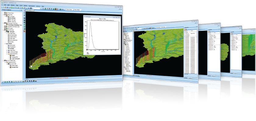
WMS - The All-in-one Watershed Solution
流域建模系統(WMS)是一個所有階段的流域水文和液壓系統綜合圖形模的環境。WMS 包括功能強大的工具來自動建模過程如自動的流域分、幾何參數計算、地理資訊系統覆蓋計算(CN、雨量深度、粗糙度係數等)、地形資料截面提取和更多!目前發行的WMS 8.4版軟體支援水文建模與HEC-1 (HEC-HMS), TR-20, TR-55, Rational Method, NFF, MODRAT, OC Rational, and HSPF。支援的水力模型包括HEC-RAS, SMPDBK, and CE QUAL W2.。現在可以進行(包括通道液壓系統與地下水相互作用)2D集成的水文建模與GSSHA。基於地理資訊系統的資料處理架構中,所有的流域建模和繪製的模擬任務將使流域建模和繪製比以往容易許多了。
特色
The complete all-in-one watershed solution
- GIS Tools
- Web-based data acquisition tools
- Terrain data import and editing tools
- Automated watershed delineation & hydrologic modeling
- Support for the most industry standard hydrologic models
- Step-by-step hydrologic modeling wizard
- Hydraulic modeling & floodplain mapping
- Storm drain modeling
- 2D (Distributed) Hydrology
- Integration with FHWA hydraulic calculation software
- Export WMS animations to GoogleTM Earth
Automated watershed delineation & hydrologic modeling
- Automatically delineate a watershed and sub-basins using digital terrain data
- Automatically compute geometric basin data such as area, slope, mean elevation, maximum flow distance and more
- With a small amount of input, compute hydrologic basin data such as time of concentration, curve number, and infiltration parameters
- Industry standard equations for computing sub-basin lag times and times of concentration are included with WMS
- Add any number of interior outlet points and let WMS subdivide the watershed automatically
- Manipulate stream networks to represent man-made features or proposed changes to the watershed
- Override derived basin boundaries to match your knowledge of the watershed
Support for most industry standard hydrologic models
- A license of WMS Floodplain or greater includes an interface for the following industry standard hydrologic models:
- HEC-1
- HEC-HMS
- TR-20
- TR-55
- Rational Method
- MODRAT
- OC (Orange County, California) Rational
- OC Hydrographic
- HSPF
- National Streamflow Statistics
- Convert and compare the results of a watershed developed for one model with any of the other models supported in WMS
- Read and compare observed hydrographs with computed hydrographs
Hydraulic modeling & floodplain mapping
- Define a stream centerline and bank stations
- Define cross section locations
- Automatically cut cross sections and derive Manning's roughness values from elevation and ground material data
- Export cross sections to the HEC-RAS or Simplified Dam Break hydraulic models
- Run the hydraulic model and read the water elevations back into WMS
- Read water surface elevation data from a hydraulic model or manually input known water surface elevations
- Create flood extents and flood depth maps using digital terrain data and water surface elevation data points
- Link the peak flow or complete hydrograph from any of the WMS-supported hydrologic models to an HEC-RAS hydraulic model
Storm drain modeling
- Draw a storm drain network or import a network from GIS
- Compute elevations, lengths, and slopes of pipes from underlying elevation data
- Link the storm drain network to your hydrologic model data
- Export the hydrologic model data and the storm drain network to EPA-SWMM or XP-SWMM
- Import existing EPA-SWMM or XP-SWMM files into WMS
2D (Distributed) hydrology
- WMS supports 2D models:
- The US Army Corps of Engineers (USACE) GSSHA model
- The HMS version of the quasi-distributed MODClark method
- Flood forecasting (depth and velocity over entire 2D domain)
- Thunderstorm (localized rainfall) flood analysis
- Surface ponding and infiltration analysis
- Wetland modeling
- Land use change impact modeling
- Groundwater/surface-water interaction modeling
- Sediment and contaminant modeling
Import what you need
- USGS DEMs - download and use any format of DEM from the USGS
- USGS NED data - seamless elevation data can be downloaded and read into WMS
- ArcGIS Raster (ASCII format) - read elevation or attribute data in gridded format from ArcGIS
- ESRI Shape files - read all shapes and attributes into WMS
- DXF and DWG CAD files - WMS now supports the latest versions of DXF and DWG
- TIFF, JPEG image files - /images along with geo-referencing information can be read by WMS
- Any data supported by ArcGIS can be read into WMS (ArcGIS license required, compatible with ArcGIS 10.0)
Software from an Industry Leader
WMS is developed by Aquaveo, an engineering services company with many years of experience developing watershed modeling solutions.
- Step-by-step tutorials and how-to videos
- Online community forum and product documentation
- Phone and email technical support
- Regularly scheduled training courses taught by expert modelers
- On-site training available
- Professional consulting services
系統需求
WMS 11.2 System Requirements
» Operating System: Windows 11
» RAM: 16GB or more recommended
» CPU: WMS software is CPU intensive. Some models and utilities integrated with WMS can take advantage of multiple processor cores simultaneously. We recommend the fastest CPU your budget allows.
» Storage: Recommended storage amount will vary depending on individual data requirements. Latest versions of WMS are very disk I/O intensive.
- Mechanical hard drive: Basic performance
- SATA solid state drive: Better performance
- NVMe solid state drive: Best performance
» Graphics: A dedicated graphics card is better than integrated graphics. A basic or mid-range nVidia card designed for gaming works best.
» Display Resolution: 1920 x 1080 or greater
版本比較
| Floodplain | Municipal | Premium | |
| WMS Core Components | |||
| - Terrain Data | V | V | V |
| - Drainage Module | V | V | V |
| - Map Module | V | V | V |
| - Streamflow (NSS) | V | V | V |
| - HY-8 Culvert Analysis | V | V | V |
| - Hydraulic Toolbox | V | V | V |
| - Hydrologic Wizard | V | V | V |
| - Rational Method Model | V | V | V |
| - MODRAT Model | V | V | V |
| - Time Series Editor | V | V | V |
| Hydrologic Modeling | |||
| - HEC-1 Model | V | V | V |
| - HEC-HMS Model | V | V | V |
| - TR-20 Model | V | V | V |
| - TR-55 Model | V | V | V |
| - OC Rational Model | V | V | V |
| - OC Hydrograph Model | V | V | V |
| - HSPF Model | V | V | V |
| 1D Hydraulic Modeling | |||
| - HEC-RAS Model Intg. | V | V | V |
| - SMPDBK Model | V | V | V |
| Storm Drain Modeling | |||
| - EPA-SWMM Model | V | V | |
| - XP-SWMM Support | V | V | |
| - HY-12 Storm Drain | V | V | V |
| Sanitary Sewer Modeling | |||
| - EPA-SWMM Sanitary | V | V | |
| Water Distribution Modeling | |||
| - EPANET | V | V | |
| 2D Hydrologic Modeling | |||
| - 2D Grid Tools | V | ||
| - ModClark Model | V | ||
| - GSSHA Model | V | ||
| - CE-QUAL-W2 Model | V | ||
| Maintenance | |||
| - First year of maintenance included | V | V | V |
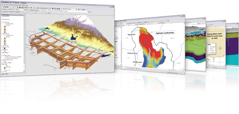
ESRI和Aquaveo很高興為您帶來 Arc Hydro Groundwater Tools,將幫助您在ArcGIS中的地下水和地表數據的管理做到更好。
根據地下水的水文數據模型電弧,這些工具將使你能夠利用ArcGIS平台透過Groundwater Analyst, Modflow Analyst, and Subsurface Analyst做歸檔,管理和預視地下水的訊息。
地下水分析師將幫助您將數據導入到您的AHGW數據模型,管理的關鍵屬性,和可視化數據。
在MODFLOW分析師您可以創建,存檔,並在ArcGIS中可看見Modflow的模型。
- Expand your ArcGIS software with groundwater and subsurface geoprocessing tools developed in collaboration with ESRI
- Georeference subsurface data including boreholes, sketched cross sections, and geovolumes
- Reduce the need for multiple applications - visualize model data inside of ArcGIS
- Store, georeference, and create GIS maps of MODFLOW model input and solution data
特色
Groundwater Analyst
Import a variety of datasets (wells, time series, cross sections, volumes) into your geodatabase, manage symbology of layers in ArcMap and ArcScene, map and plot time series, and create common products such as water level, water quality, and flow direction maps.
Subsurface Analyst
Create and visualize both 2D & 3D geologic models, starting with classification and visualization of borehole logs, creation and editing of cross sections, and generation of 3D geosections and geovolumes.
MODFLOW Analyst
Edit, archive, and visualize MODFLOW models within ArcMap. Tools in the toolkit enable you to import an existing model into the geodatabase and geo-reference the model so you can visualize and analyze the results in context with other GIS data, as well as modify models from GIS features.
系統需求
Arc Hydro Groundwater System Requirements
- ArcGIS®: Version 9.3 - 10.8 (users with a Basic level or higher license)
- Microsoft® .NET Framework Version 3.5 (will be installed with Arc Hydro Groundwater if not present)
- .NET support needs to be enabled in ArcGIS after installation of Arc Hydro Groundwater is complete
- ESRI's 3D Analyst is required to visualize 3D features
- ESRI's Spatial Analyst is required for interpolation
CityWater 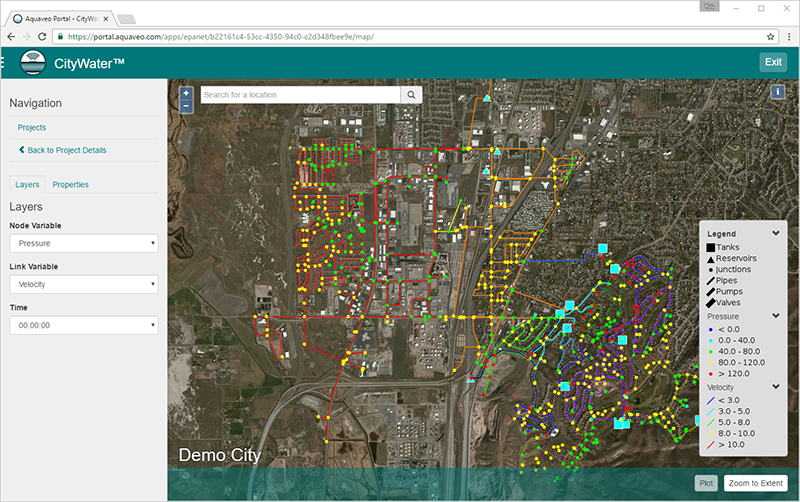 is the premier EPANET web application for water distribution management. The intuitive, interactive presentation and access-anywhere convenience of CityWater allows you to unlock the data in your EPANET models and add value to the everyday operations of your distribution system. Plus, the subscription-based pricing means you don't need to pay for expensive software you don't use.
Visualize the distribution of pressure, head, velocity, flow and other important variables on an interactive web map. Present model results anywhere and at a moment's notice using your phone, tablet, or laptop. Look up any network property or model result on the go by accessing CityWater on your phone. Plot how model results like pressure or velocity change over time and export the plot to an image to share with contractors or place in a report. Enhance your understanding of your network and quickly identify inefficiencies with the conceptual schematic view and analysis tools.
特色
CityWater Advantages
- Convenient subscription-based access
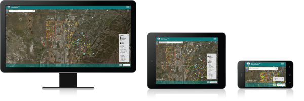
- Works on most operating systems and devices: Windows®, Mac®, Android™, iOS, etc.
- No installation required -- only a modern web browser is needed
- Upload any EPANET input file and access it on all devices
- Improve the presentation of EPANET simulation results to non-technical audiences
- Provide instant feedback on the model results using the annotation features
Unlock EPANET Data at All Levels
Decision Support
- Enhance presentations to non-technical audiences
- Answer stakeholder questions with illustrative visualization
- Present anywhere, anytime, and on any device
Operations
- Lookup model attributes on-the-go
- Annotate model with problems as they are discovered
- Respond to customer questions with real model data
Consulting
- Manage accounts for your customers
- Deliver the latest models instantly in an interactive format
- Add value to your EPANET modeling services
系統需求
CityWater System Requirements
- Operating System: Works on most OS’s including Windows, MacOS, Android, and iOS.
- Browser: Most modern browsers including Chrome, Edge, and Safari with Javascript enabled.
- Model Format: Native EPANET format supported (WaterGEMS, InfoWater, etc.). Modifications may be required for some EPANET implementations.
- Network: Your connection to the Internet will largely determine system performance.
版本比較
| CityWater | |
| CityWater Core Components | |
| - Network Map Layers | V |
| - Report Map Layers | V |
| - Zone Map Layers | V |
| - Element Timeseries Plots | V |
| - Element Property Lookup | V |
| - Element Annotation | V |
| - Address Lookup | V |
| - Pattern and Curve Plots | V |
| - Export Layers as Shapefiles | V |
| - Upload Any EPANET Model | V |
| - Animate Layers Across Simulation | V |
| Scenario Management Add-on | Add-on |
| - Create Scenarios from within Projects | |
| - Edit Model Properties and Scenario Options | |
| - Run and Re-run Scenarios | |
| Fire Flow Analysis Add-on | Add-on |
| - Peak Day Fire Flow Analysis | |
| - Fire Flow Availability Analysis | |
| - Fire Flow Planning Analysis | |
| Pressure Zone Schematic Add-on | Add-on |
| - Automatic Pressure Zone Delineation | |
| - Pressure Zone Schematic Visualization | |
| - Size Pressure Zones by Value or Type | |
| - Customize Pressure Zone Labels | |
| - Sort Pressure Zones by Relative Elevation or Head | |
| Energy Add-on (requires Pressure Zone Schematic) | Add-on |
| - Run Energy Analysis Algorithms | |
| - Identify Looping Inefficiencies | |
| - Identify Leaping Inefficiencies | |
| - Identify Loading Inefficiencies | |
| - Identify Losing Inefficiencies | |
| - Identify Level Inefficiencies | |
| Client Account Management | Add-on |
| - Create Organizations for your Clients | |
| - Create User Accounts for your Clients | |
| - Manage Projects for your Clients | |
| - 10% of License Fee Waived per Client | |
| Enterprise Option | 請洽詢友環業務 |
| - Dedicated Server | |
| - Custom Domain | |
| - Premium Support | |
| Limitations | |
| - Storage | 4GB |
| - Users* | 10 |
| - Concurrent Logins per User | 1 |
| - Maximum Pipe Count** | 50000 |
| - Increase in model size of 50% or more will incur additional fees*** | Prorated |
Local & Flex Software Licensing
Using the latest versions of our desktop software, we offer flexible licensing options so that you can work where and when you need to.
Both license methods are activated over the Internet when a license is purchased or maintenance is updated. Licenses enable the modules or components that you have purchased and contain information about the expiration of the license & its maintenance.
Supported Versions:
- AHGW 3.5+
- GMS 10.5+
- SMS 13.1+
- WMS 11.1+
| Local License (single-use) |
Flex License | |
| Enable a license on a single computer | V | V |
| Host multiple license configurations on a single computer | V | V |
| Use on a Mac® with Boot Camp® to run Windows® | V | V |
| Use on a Mac with virtualization software such as VMWare Fusion® or Parallels | V | V |
| Use with a virtual machine or Remote Desktop | V | V |
| Share a license over a network | V | |
| Check-out/check-in a license for remote work | V |