A numerical modelling support system designed to process, analyze, and visualize complex geo-scientific data.
mView 支援所有關於環境數據視覺化及3D數值模型。mView 最初開發支援尤卡山項目(TOUGH、FEHM、NUFT、ASHPLUME和WAPDEG) 中使用數值模型的前製、後製和可視化的要求。
Geofirma 公司擴大 mView 支援其他的模型(MODFLOW/ MODPATH、FRAC3DVS、SWIFT),整合成模型結果及現場數據(鑽孔記錄、地質物理、抽樣結果),並提供廣泛的模型預處理和後處理能力。
mView是設計用來處理分析和可視化複雜的地質科學數據及數值建模支援系統,可全方位支援數值模擬過程。
- 鑽孔地質
- 土壤和地下水的分析結果
- 數值高程模型(DEM)和地質表面
- 水位數據
- 地理訊息系統的數據,例如道路、水的功能等等。
產品特色
整合田野及地圖數據資料
- 資料可以使用標準格式匯入mView。例如DXF、ArcInfo匯出、Surfer軟體網格、以及通用的表單、網格、XYZ數據
- enlargeOnce數據是在mView內建,可以操縱數據、可視覺化和匯出。例如,mView的數據提取功能可藉由擷取鑽孔地質訊息和水位資料,以協助產生表面。
- mView支援多種座標系統,並提供透明的座標系統轉換。例如,UTM網格和站點網格可以很容易地一起使用。對於可以定義和可同時使用座標系統的數量沒有限制。
- enlargeOnce數據是在mView內,可以操縱、可視覺化和匯出。例如,mView的數據提取功能可擷取鑽孔地質訊息和水位資料,以協助產生表面。
- mView支援多種座標系統,並提供透明的座標系統轉換。例如,UTM網格和站點網格可以容易地一起使用。對於可以定義和可同時使用座標系統的數量沒有限制。
數值模型開發
- 視覺化概念模型,例如結合地質層和地質鑽孔,評估2D和3D污染物分佈
- 生成二維和三維常規有限差或不規則有限元網格
- 對於分配/指定網格塊/元素屬性分佈廣泛的範圍
- 選擇元素/節點/面來定義的邊界條件、模型屬性
- 產生特定模型匯出檔案
mView擁有一套完整的生成二維和三維有限差分和有限元網格工具。
模型特定座標系統可以定義和根據ISM表面或其它準則產生網格層,如厚度、絕對標高等
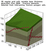
經過模型仿真完成,mView能夠直接轉換模式從以下任一模型匯出文件:
- TOUGH
- FEHM
- NUFT
- ASHPLUME
- WAPDEG
- MODFLOW/ MODPATH
- FRAC3DVS
SWIFT表格匯出檔案也可以直接匯入到mView。
不同於許多軟體產品,mView 不限於只從一個模型分析和可視化模型結果
模型結果分析
- 模型比較結果現場數據
- 校準統計計算
- 結果擷取和數據操作
眾多分析功能可在mView取得,其中包括:
- 單變量統計
- 由屬性、位置和任何規格產生的結果擷取
- 從不飽和模型的結果擷取地下水位位置
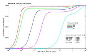
- 數學運算(例如: 從兩次中計算結果之間的差異、或從同一次運行中進行兩次步驟); 建立 CDF(累積分配函數,又稱累加機率函數)和資料擷取(如查找資料的第95百分位)
- 分析計算的中間及最終匯出可視化
視覺化
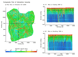
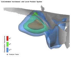
- 二維和三維空間曲線的可視化領域和載體
- 二維和三維非空間曲線的繪製時間序列及累積分配函數
- 多模型結果的比較: 包括支援不同的座標系統
- 報告品質2D和3D數值/海報與PostScript匯出
- 整合動畫支援
特殊應用
- 層次模型(巢式模型)支援
- MODPATH整點允許創建MODPATH匯入檔案,根據從模型產生的流結果而不是MODFLOW流結果
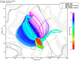
nSights provides numeric well-test analysis with integrated uncertainty assessment and inverse modelling.
nSights provides state-of-the-art well-test capabilities for analyzing hydraulic and gas tests conducted in complex test environments. nSights features and capabilities include:
- Multiple conceptual models
-Dual porosity, leakage (from above and/or below), well-bore skin (enhancement or damage)
-Flow dimension capability allows for interpretation/analysis of non-radial flow such as fracture systems
- Numeric simulator
-Compensates for non-ideal test procedures such as pumping rate changes
-Allows incorporation of long-term pre-test pressure histories
-Supports combinations of conceptual models not supported by analytic techniques (e.g. dual porosity aquifer with leakage)
- Advanced graphical analysis techniques
- Derivative plots, decline plots, pulse/slug and flow dimension analysis
-Advanced derivative calculation for noisy field data
-Time and space superposition
- Optimization (inverse modelling)
- Automatic fitting of field data with Levenberg-Marquadt and Simplex methods
-Multiple constraints (e.g fit derivative & cartesian results, fit results from multiple observation wells simultaneously)
-Advanced statistical processing for confidence region estimation
-Can incorporate Latin Hyper-Cube or Monte-Carlo sampling of uncertain parameters to determine range/distribution of possible hydraulic parameters
- Data pre-/post-processing
-Extensive facilities for importing, cleaning and processing field data
-Report quality 2D and 3D plotting

paCalc is a modelling framework and library of integrated sub-models to estimate risk and contaminant mass flux.
Geofirma also offers services to create application-specific analysis and visualization software. Our C++ framework of graphics and data processing objects can be used as a basis for proprietary software in Windows and Linux.
paCalc is a modelling framework that estimates risk and contaminant mass flux associated with contaminated sites or waste disposal facilities. paCalc consists of a sampling facility and a library of integrated sub-models, including: source terms, unsaturated zone and saturated zone flow and transport, and human risk/dose calculation. Sub-models are linked into a network pathway model defined by the user. Stochastic distributions are defined for uncertain variables. Multiple realizations of the network are executed and calculated output post-processed.
paCalc was originally developed by Geofirma staff for use on the Yucca Mountain program. Geofirma has expanded paCalc capabilities to address concerns associated with chemical contaminants and increased it's applicability for the assessment of contaminated sites and hazardous/chemical disposal facilities.
paCalc is licensed software available from Geofirma. We provide sales, support and training for paCalc.

About us
Geofirma is an employee-owned Canadian corporation operating from its head office in Ottawa, Ontario, Canada. For over 20 years, we have provided broad range of geoscientific and environmental engineering consulting services. Geofirma is recognized as a leader in site characterization and predictive modelling for radioactive waste disposal. We operate under a quality management system which is ISO 9001-2008 certified.


